


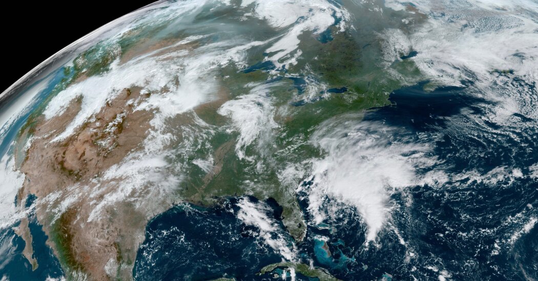
Meteorologists said a weather system that was brewing along the East Coast was expected to become a tropical storm before soaking the Carolinas and the Mid-Atlantic region with up to seven inches of rain through part of the weekend.
Tropical storm conditions were already spreading toward the coast of North Carolina on Friday morning. Nearly seven million people from the Carolinas to Delaware were under tropical storm warnings, according to the National Weather Service.
The National Hurricane Center estimated that the storm, currently called Potential Tropical Cyclone Sixteen, had sustained winds of about 50 miles per hour and was about 245 miles south of Cape Hatteras, N.C. Tropical disturbances are typically named when they have sustained winds of 39 m.p.h. Once winds reach 74 m.p.h., a storm becomes a hurricane; at 111 m.p.h., it becomes a major hurricane.
Though the storm has not yet been given a name by the Hurricane Center, it has winds that are of tropical storm force, and it is beginning to develop a warm core, but it hasn’t rid itself of some “frontal features associated with it,” forecasters said. That’s a technicality that is keeping it from getting the name, even though its effects on the North Carolina coast will be the same.
Forecasters believe the storm system will strengthen over the next day or so. The center of the storm is expected to approach the coast of North Carolina through Friday night, moving north over Virginia and the Delmarva Peninsula on Saturday.
Rainfall totals across the area will vary and could spark some flooding. Portions of North Carolina and Virginia could see up to seven inches while points northward could see up to four inches. Forecasters also warned that the system could spawn tornadoes through Saturday.
Tropical storm warnings were in effect early Friday from Cape Fear, N.C., north to Fenwick Island, Del. They were also in effect for Albemarle Sound and Pamlico Sound in North Carolina, as well as for some coastal areas of Maryland.
Just last weekend, Lee produced tropical-storm conditions in New England as it made landfall in Canada. This weekend, similar tropical-storm-force winds and some coastal flooding from storm surge are possible in the Carolinas and Virginia.
When it earns a name, it could be considered a subtropical storm first. This is common when a typical weather system, which gets its energy from competing cold and warm air masses, begins to transition into a tropical cyclone that pulls energy from warm ocean temperatures. Forecasters believe the core of the storm will probably have become fully tropical when it reaches North Carolina’s coast Saturday morning. This means the stronger winds could probably be found closer to the storm’s center.
It’s possible for this storm to have a smaller-scale tropical cyclone embedded within the larger envelope of a nontropical system, Daniel Brown, a senior specialist at the Hurricane Center, said.
By Sunday and Monday, this system is likely to be much weaker, with lingering heavy rain, as it inches north over the Chesapeake Bay and the Delmarva Peninsula, forecasters with the Weather Prediction Center said.
The Atlantic hurricane season started on June 1 and runs through Nov. 30.
In late May, the National Oceanic and Atmospheric Administration predicted that there would be 12 to 17 named storms this year, a “near-normal” amount. On Aug. 10, NOAA officials revised their estimate upward, to 14 to 21 storms.
There were 14 named storms last year, after two extremely busy Atlantic hurricane seasons in which forecasters ran out of names and had to resort to backup lists. (A record 30 named storms took place in 2020.)
This year features an El Niño pattern, which arrived in June. The intermittent climate phenomenon can have wide-ranging effects on weather around the world, and it typically impedes the number of Atlantic hurricanes.
In the Atlantic, El Niño increases the amount of wind shear, or the change in wind speed and direction from the ocean or land surface into the atmosphere. Hurricanes need a calm environment to form, and the instability caused by increased wind shear makes those conditions less likely. (El Niño has the opposite effect in the Pacific, reducing the amount of wind shear.)
There is solid consensus among scientists that hurricanes are becoming more powerful because of climate change. Although there might not be more named storms overall, the likelihood of major hurricanes is increasing.
Climate change is also affecting the amount of rain that storms can produce. In a warming world, the air can hold more moisture, which means a named storm can hold and produce more rainfall, like Hurricane Harvey did in Texas in 2017, when some areas received more than 40 inches of rain in less than 48 hours.
Researchers have also found that storms have slowed down, sitting over areas for longer, over the past few decades.
When a storm slows down over water, the amount of moisture the storm can absorb increases. When the storm slows over land, the amount of rain that falls over a single location increases; in 2019, for example, Hurricane Dorian slowed to a crawl over the northwestern Bahamas, resulting in a total rainfall of 22.84 inches in Hope Town during the storm.
Other potential effects of climate change include greater storm surge, rapid intensification and a broader reach of tropical systems.
Derrick Bryson Taylor contributed reporting.