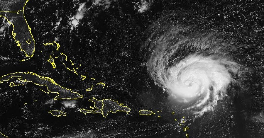
Hurricane Lee grabbed the attention of forecasters and social media last week as the rapidly intensifying storm moved west across the open waters of the Atlantic.
It is easy to look at a map showing a major hurricane with a forecast path pointed directly at the United States and think the East Coast is in for it. But as of Thursday night, that scenario was not the most probable outcome. Even if it were, Lee wouldn’t arrive until late this coming week, which is beyond the official forecast from the experts at the National Hurricane Center.
Here’s what we know about the hurricane:
What is Lee’s current location and path?
As of 11 a.m. on Sunday, Hurricane Lee was about 270 miles north-northeast of the northern Leeward Islands, which are in the northeastern Caribbean, and the storm was moving west-northwest at 8 miles per hour, the Hurricane Center said.
It had maximum sustained winds of 110 m.p.h., making it a Category 2 storm. Some strengthening was forecast during the next couple of days, the Hurricane Center said.
Lee currently does not threaten any land, and there are no coastal watches or warnings in effect, but dangerous surf conditions generated by the storm are expected to affect parts of the East Coast of the United States starting on Sunday, the Hurricane Center said.
Meteorologists are fairly confident that Lee will stay north of the Caribbean. Several forecast models suggested the storm would veer north, but it remained unclear if and when that would happen — and whether it would turn before threatening the United States.
“It remains too soon to know what level of impacts, if any, Lee might have along the U.S. East Coast, Atlantic Canada or Bermuda late next week, especially since the hurricane is expected to slow down considerably over the southwestern Atlantic,” the Hurricane Center said.
Go here for the latest maps and trackers as Lee moves through the Atlantic.
How big is this storm going to get?
Lee intensified rapidly on Thursday, with its wind speeds doubling from 80 to 160 m.p.h. It is expected to remain a major hurricane (Category 3 or higher, with wind speeds of at least 111 m.p.h.) through early next week, according to the Hurricane Center.
What are the chances it will hit the U.S. East Coast?
There is some chance, but it is currently not the likely outcome. It might also hit Canada or stay farther east and move across Bermuda.
Tell me what the models show. (Also, what’s a spaghetti model?)
One version of a model last weekend suggested that the East Coast could get hit, a possibility that has lingered in the minds of some forecasters and amateur weather watchers, in part because of widespread social media hype.
But when you look at all the versions of the model, there is not an overwhelming consensus on where the center of the hurricane will go after this weekend, with some outliers close to the East Coast.
Sometimes, multiple models are displayed on a single map with lines that plot where that computer simulation believes the center of the storm will be five, seven or even 14 days in the future.
Known as spaghetti models, these mapped model outputs get their name from their resemblance to long strands of pasta.
The closer the lines are to one another, the more confidence it gives forecasters in what the storm might do. For the next few days, there is a pretty reliable consensus that the storm will track northwest.
When the spaghetti lines spread wider apart, forecasters have many more possibilities to contend with. There is a lot of spread beyond this weekend, which is why this storm will be important to keep an eye on. Right now, everything is on the table.
What has this year’s hurricane season been like so far?
We’re a little over halfway through the Atlantic hurricane season, which started on June 1 and runs through Nov. 30.
In late May, the National Oceanic and Atmospheric Administration predicted that there would be 12 to 17 named storms this year, a “near-normal” amount. On Aug. 10, NOAA officials revised their estimate upward, to 14 to 21 storms, and the last few weeks have been busy.
When it formed on Tuesday, Lee became the 12th named storm of this year’s Atlantic season. (And the 13th if you count an unnamed storm in January that experts at the Hurricane Center said should have been named.) It is also the eighth since Aug. 20, when two tropical storms, Emily and Franklin, formed. A week later saw the arrival of Tropical Storm Idalia, which made landfall along Florida’s Gulf Coast as a Category 3 hurricane on Aug. 30.
Tropical Storm Margot formed on Thursday and is expected to strengthen into a hurricane.
There is consensus among scientists that hurricanes are becoming more powerful because of climate change. Although there might not be more named storms overall, the likelihood of major hurricanes is increasing.
Climate change is also affecting the amount of rain that storms can produce.
In a warming world, the air can hold more moisture, which means a named storm can hold and produce more rainfall, like Hurricane Harvey did in Texas in 2017, when some areas received more than 40 inches of rain in less than 48 hours.
Researchers have also found that, over the past few decades, storms have slowed down, sitting over areas for longer.
When a storm slows down over water, the amount of moisture the storm can absorb increases. When the storm slows over land, the amount of rain that falls over a single location increases; in 2019, for example, Hurricane Dorian slowed to a crawl over the northwestern Bahamas, resulting in a total rainfall of 22.84 inches in Hope Town during the storm.
Anastasia Marks and Eduardo Medina contributed reporting.


